Overview: Where Exactly Is Yogyakarta?
Yogyakarta location in Indonesia places it in the south-central region of Java Island, one of the country’s most populous and culturally significant islands. Often called “Jogja” by locals and visitors alike, Yogyakarta serves as both a city and a special administrative region. The Yogyakarta geography and region is characterized by its position between the Indian Ocean to the south and the imposing Mount Merapi volcano to the north, creating a diverse landscape that ranges from coastal plains to volcanic highlands.
As a Yogyakarta Java cultural city, it holds special status within Indonesia as the only region still governed by a pre-colonial monarchy. The Sultan’s Palace (Kraton) stands at the heart of the city, symbolizing Yogyakarta’s unique position as a cultural center where ancient traditions remain alive alongside modern development. This special status reflects the region’s historical importance during Indonesia’s struggle for independence when Yogyakarta served as the nation’s capital from 1946 to 1948.
Yogyakarta’s Position on the Island of Java
Yogyakarta on Java Island occupies a strategic position in the south-central part of Java, Indonesia’s most developed island. When looking at Yogyakarta on the map, you’ll find it nestled between East Java and Central Java provinces. This location has historically made it an important crossroads for trade, culture, and politics throughout Java’s history.
The city sits approximately 7°48′5″S 110°21′52″E on a fertile plain, with several key geographical features defining its surroundings:
- To the north: Mount Merapi, one of Indonesia’s most active volcanoes
- To the south: The Indian Ocean coastline with black sand beaches
- To the east: The Solo River (Bengawan Solo) and the city of Surakarta
- To the west: The Menoreh Hills and the Progo River valley
Yogyakarta on Java Island benefits from this diverse geography, which has shaped its cultural development and agricultural practices for centuries. The fertile volcanic soil from Mount Merapi has made the surrounding areas particularly productive for farming, while the coastal regions offer fishing and sea trade opportunities. This geographical diversity contributes to Yogyakarta’s appeal as a destination that offers everything from mountain adventures to beach relaxation, all within a relatively compact area.
Is Yogyakarta a City or a Province?
One common source of confusion for travelers is understanding whether Yogyakarta is a city or a province. The answer is actually both. Yogyakarta province and city exist as two distinct but related entities:
1. The Special Region of Yogyakarta (Daerah Istimewa Yogyakarta)
This is a province-level administrative region with special status in Indonesia. What makes the Yogyakarta province and city unique is that it’s the only region in Indonesia still governed by a pre-colonial monarchy. The Sultan of Yogyakarta serves as the hereditary governor of the province, a special arrangement that recognizes the region’s historical and cultural significance. The Special Region covers an area of approximately 3,185 square kilometers and includes four regencies (Sleman, Bantul, Kulon Progo, and Gunungkidul) plus the city of Yogyakarta itself.
2. Yogyakarta City (Kota Yogyakarta)
This is the capital city of the Special Region, covering about 32.5 square kilometers at the heart of the province. When most tourists refer to visiting “Yogyakarta,” they typically mean the city, which contains the Sultan’s Palace (Kraton), Malioboro Street, and other key attractions. The city is further divided into 14 districts and serves as the cultural, educational, and economic center of the region.
This dual nature of Yogyakarta province and city reflects its unique historical development and special status within Indonesia. For travelers, it’s helpful to understand this distinction when planning your visit, as some attractions (like Borobudur and Prambanan temples) are located within the Special Region but outside the city limits.
Yogyakarta’s Location Within Indonesia’s Regions
To fully understand where Yogyakarta is located, it’s helpful to consider its position within Indonesia’s broader geographical context. Indonesia is the world’s largest archipelago, comprising over 17,000 islands stretching across the equator between the Indian and Pacific Oceans. Within this vast country, Yogyakarta location in Indonesia places it on Java, the country’s most populous and economically significant island.
1. Yogyakarta Within Java
Yogyakarta in Central Java region positions it strategically between West Java (where the capital Jakarta is located) and East Java (home to Indonesia’s second-largest city, Surabaya). Though officially a separate administrative entity from Central Java Province, Yogyakarta is geographically embedded within what is culturally considered the Central Java region, which is regarded as the historical heartland of Javanese civilization.
2. Yogyakarta Relative to Other Major Islands
Looking at Yogyakarta on the map of Indonesia, you’ll find it positioned:
- Approximately 450 km southeast of Jakarta on Java
- About 500 km west of Bali, Indonesia’s most famous tourist destination
- South of Borneo (Kalimantan) across the Java Sea
- West of Sulawesi and the Lesser Sunda Islands
3. Yogyakarta in Indonesia’s Tourism Landscape
The Yogyakarta in Central Java region serves as a crucial hub in Indonesia’s cultural tourism corridor. It forms part of a popular tourist route that often includes Jakarta, Bandung, Yogyakarta, and Bali. This central position makes it an essential stop for travelers seeking to experience Indonesia’s cultural heritage before or after visiting the beaches and resorts of Bali.
How Far Is Yogyakarta From Jakarta and Bali?
For travelers planning a trip to Indonesia, understanding the Yogyakarta distance from Jakarta and other major destinations is essential for effective itinerary planning. Yogyakarta’s central position on Java makes it accessible from several key Indonesian cities and tourist destinations.
1. Distance from Jakarta to Yogyakarta
The Yogyakarta distance from Jakarta is approximately 450 kilometers (280 miles) as the crow flies. Travel options between these cities include:
- By Air: 1 hour 15 minutes (direct flight)
- By Train: 7-8 hours (executive class train)
- By Road: 10-12 hours (depending on traffic conditions)
2. Distance from Yogyakarta to Bali
Yogyakarta to Bali is approximately 500 kilometers (310 miles), though you must cross the Java Sea. Travel options include:
- By Air: 1 hour 20 minutes (direct flight from Yogyakarta to Denpasar)
- By Train and Ferry: 12-14 hours (train to Banyuwangi, then ferry to Gilimanuk, Bali)
3. Distance from Yogyakarta to Other Major Cities
Other important Yogyakarta distance from Jakarta and major Indonesian cities include:
- Yogyakarta to Surabaya: 300 km (4-5 hours by train)
- Yogyakarta to Solo (Surakarta): 60 km (1 hour by car or train)
- Yogyakarta to Semarang: 130 km (2-3 hours by car or train)
These distances make Yogyakarta an ideal stop on a multi-city Indonesian itinerary, allowing travelers to experience Java’s cultural heartland before or after visiting other major destinations. The excellent transportation connections, particularly by air and rail, have contributed to Yogyakarta’s popularity as a tourism hub within Indonesia.
Yogyakarta on the Map: Coordinates and Surrounding Areas
Precisely pinpointing Yogyakarta on the map requires understanding its geographical coordinates and the surrounding landscape. The city of Yogyakarta is located at approximately 7°48′5″S 110°21′52″E in the southern part of Java Island. This location places it in a geographically diverse region with several distinctive features that have shaped its development and culture.
1. Elevation and Topography
The Yogyakarta geography and region sits at an elevation of about 113 meters (371 feet) above sea level. The topography of the area slopes gradually from north to south, with the northern areas near Mount Merapi at higher elevations and the southern coastal regions at sea level. This gradient creates distinct climatic zones and ecosystems within a relatively small area.
2. Key Geographical Features
Several notable geographical features define Yogyakarta on the map:
- Mount Merapi: Located about 28 km north of the city center, this active stratovolcano rises to 2,930 meters and significantly influences the region’s geology, agriculture, and culture.
- Progo and Opak Rivers: These waterways flow through the region, providing irrigation for agriculture and natural boundaries.
- Southern Beaches: The coastline along the Indian Ocean includes beaches like Parangtritis, approximately 27 km south of the city.
- Limestone Hills: The Gunungkidul area to the east features distinctive karst formations with caves and underground rivers.
3. Climate Conditions
The Yogyakarta geography and region experiences a tropical monsoon climate with distinct wet and dry seasons:
- Wet Season: November to April, with heaviest rainfall in January and February
- Dry Season: May to October, with July and August being the driest months
- Average Temperature: 26-27°C (79-81°F) year-round, with minimal seasonal variation
Understanding these geographical aspects helps travelers appreciate how Yogyakarta on the map relates to its cultural development, agricultural practices, and tourism attractions. The diverse landscape allows visitors to experience everything from volcanic highlands to coastal areas within a single region.
Neighboring Cities and Regencies Around Yogyakarta
The Special Region of Yogyakarta is surrounded by several important cities and regencies that form part of its broader cultural and economic sphere. Understanding these neighboring areas helps travelers plan comprehensive itineraries that include the full range of attractions in and around where Yogyakarta is located.
1. Regencies Within the Special Region
The Special Region of Yogyakarta consists of the city of Yogyakarta and four surrounding regencies:
- Sleman Regency: Located north of Yogyakarta city, it extends to the slopes of Mount Merapi and contains important attractions like Prambanan Temple and several universities.
- Bantul Regency: South of the city, extending to the coast, known for traditional crafts villages and beaches.
- Kulon Progo Regency: To the west, featuring the Menoreh Hills and the new Yogyakarta International Airport.
- Gunungkidul Regency: To the east and southeast, famous for its karst landscape, caves, and scenic beaches.
2. Neighboring Cities Outside the Special Region
Several important cities lie just beyond the borders of the Special Region:
- Surakarta (Solo): About 60 km east of Yogyakarta, this cultural city is the sister royal city to Yogyakarta with its own palace and traditions.
- Magelang: Located about 40 km northwest of Yogyakarta, it’s the gateway to Borobudur Temple.
- Klaten: Situated between Yogyakarta and Solo, it contains several smaller temples and natural attractions.
- Purworejo: West of Yogyakarta, beyond Kulon Progo.
- Wonosari: The main town in Gunungkidul Regency, serving as a base for exploring the eastern caves and beaches.
3. Important Satellite Towns
Within the greater Yogyakarta metropolitan area, several smaller towns serve as important satellites:
- Kaliurang: A hill station on the southern slopes of Mount Merapi, popular for its cooler climate.
- Kotagede: Historically the first capital of the Mataram Sultanate, now famous for silver crafts.
- Imogiri: Location of the royal cemetery where Yogyakarta and Surakarta sultans are buried.
- Prambanan: A town that takes its name from the famous temple complex nearby.
Geographic Features That Shape Yogyakarta’s Location
The Yogyakarta geography and region has been profoundly shaped by several key geographical features that have influenced its historical development, cultural practices, and economic activities. These natural elements create the distinctive character of where Yogyakarta is located and continue to impact life in the region today.
1. Mount Merapi: The Fire Mountain
The most dominant geographical feature influencing the Yogyakarta geography and region is Mount Merapi, one of Indonesia’s most active volcanoes. Rising to 2,930 meters (9,610 feet), this stratovolcano has erupted regularly since 1548, with significant eruptions in 2006 and 2010. Despite its destructive potential, Mount Merapi plays several crucial roles in the region:
- Its volcanic ash creates extremely fertile soil that supports productive agriculture
- It provides building materials like volcanic stone used in temple construction
- It holds deep spiritual significance in Javanese culture and cosmology
- It creates a natural watershed that feeds the region’s river systems
2. The Southern Coastal Zone
The southern boundary of the Yogyakarta in Central Java region is formed by the Indian Ocean coastline, which features distinctive black sand beaches created by volcanic material. This coastal zone includes:
- Parangtritis Beach: The most famous beach in the region, associated with legends of the Queen of the South Seas
- Sand dune formations along parts of the coast
- Fishing communities that maintain traditional practices
- Areas of coastal erosion and dynamic shoreline changes
3. River Systems and Watersheds
Several important rivers flow through the Yogyakarta geography and region, generally running from north to south:
- Progo River: Forms the western boundary of the region
- Opak River: Runs through the central part of the region
- Code River: Flows through Yogyakarta city
- Gajahwong River: Another urban waterway in eastern Yogyakarta
4. Karst Landscape of Gunungkidul
The eastern part of the Special Region features a distinctive karst topography characterized by:
- Limestone hills and underground river systems
- Caves such as Jomblang and Pindul that have become tourist attractions
- Challenges for water access that have influenced settlement patterns
- Unique ecosystems adapted to the limestone environment
These geographical features have collectively shaped where and how people live in the Yogyakarta in Central Java region, influencing everything from agricultural practices to architectural styles, transportation routes, and cultural beliefs. For visitors, understanding these features provides deeper insight into the region’s cultural landscape and helps explain the distribution of key attractions.
Why Yogyakarta’s Location Matters for Tourism
The strategic position of Yogyakarta Java cultural city has made it one of Indonesia’s premier tourist destinations. Its location offers several advantages that have contributed to its popularity among both domestic and international travelers. Understanding these factors helps explain why Yogyakarta features prominently in many Yogyakarta travel location guide resources.
1. Cultural Crossroads
As a Yogyakarta Java cultural city, its location at the heart of Java has historically made it a meeting point for various cultural influences:
- Hindu-Buddhist heritage from the 8th-10th centuries visible in temple architecture
- Islamic influences following the establishment of the Mataram Sultanate
- Dutch colonial elements from the 18th-20th centuries
- Contemporary Javanese arts and crafts traditions
This cultural convergence creates a rich tapestry that attracts cultural tourists seeking authentic experiences.
2. Gateway to Ancient Wonders
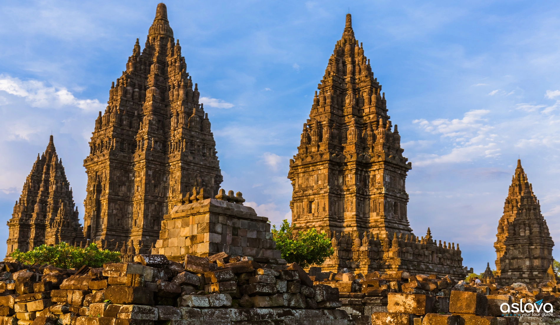
Yogyakarta’s proximity to two UNESCO World Heritage Sites makes it an essential stop on many Yogyakarta travel location guide itineraries:
- Borobudur Temple: The world’s largest Buddhist temple, located about 40 km northwest of Yogyakarta
- Prambanan Temple: A magnificent Hindu temple complex just 17 km northeast of the city
These monumental structures draw thousands of visitors who base themselves in Yogyakarta while exploring these ancient sites.
3. Natural Diversity Within Reach
The varied Yogyakarta geography and region allows visitors to experience multiple landscapes in a single trip:
- Volcanic adventures on Mount Merapi
- Beach experiences along the southern coast
- Cave explorations in the eastern karst region
- Rural rice field landscapes throughout the region
This diversity enables tour operators to offer varied experiences without requiring long-distance travel.
4. Strategic Position on Tourist Routes
Yogyakarta’s location places it strategically on popular Indonesian tourist circuits:
- It forms part of the Jakarta-Yogyakarta-Bali route followed by many international visitors
- It connects easily to other Central Java attractions like Dieng Plateau and Solo
- It serves as a gateway to eastern Indonesia for travelers moving eastward
This positioning has led to excellent transportation infrastructure, making Yogyakarta easily accessible.
5. Educational Tourism Hub
As a Yogyakarta Java cultural city with numerous universities, its location has fostered educational tourism:
- Language study programs for foreigners learning Indonesian
- Cultural immersion experiences
- Research opportunities in archaeology, anthropology, and arts
- Student exchange programs with international institutions
These factors combine to make Yogyakarta’s location a key asset in Indonesia’s tourism landscape, explaining why it features prominently in any comprehensive Yogyakarta travel location guide. The accessibility, cultural significance, and diversity of experiences available make it an essential destination for understanding Indonesia’s rich heritage.
How to Get to Yogyakarta From Major Indonesian Cities
For travelers planning to visit where Yogyakarta is located, understanding the transportation options is essential. The city is well-connected to other major Indonesian destinations, making it accessible by various modes of transport. This section of our Yogyakarta travel location guide outlines the primary ways to reach Yogyakarta from key cities across Indonesia.
1. By Air: Flying to Yogyakarta
Yogyakarta is served by Yogyakarta International Airport (YIA), located in Kulon Progo Regency, about 45 km from the city center:
- From Jakarta: Multiple daily flights (1 hour 15 minutes)
- From Bali/Denpasar: Several daily flights (1 hour 20 minutes)
- From Surabaya: Daily flights (1 hour)
- From Singapore and Kuala Lumpur: International flights available several times weekly
The older Adisutjipto International Airport still handles some domestic flights but is being phased out for commercial operations.
2. By Train: Rail Connections to Yogyakarta
Yogyakarta is a major station on Java’s southern railway line, with excellent connections:
- From Jakarta: Executive trains (7-8 hours), including overnight sleeper services
- From Surabaya: Regular train services (4-5 hours)
- From Bandung: Daily train connections (6-7 hours)
- From Solo: Frequent commuter trains (1 hour)
Yogyakarta Station (Tugu) is conveniently located near the city center, making train travel a comfortable and scenic option.
3. By Bus: Road Connections
An extensive network of buses connects Yogyakarta to cities across Java:
- From Jakarta: Executive buses (10-12 hours)
- From Surabaya: Regular bus services (6-7 hours)
- From Semarang: Frequent bus connections (3-4 hours)
- From Solo: Shuttle buses (1 hour)
Yogyakarta has several bus terminals, with Giwangan serving as the main long-distance terminal.
4. By Car: Self-Drive or Private Transfer
For those preferring flexibility, driving to Yogyakarta is an option:
- From Jakarta: Via the Trans-Java Toll Road (8-9 hours)
- From Surabaya: Via the northern coastal road or inland route (5-6 hours)
- From Semarang: Direct route south (3 hours)
Car rental services are available in major cities, or private transfers can be arranged through travel agencies.
5. Combined Transportation Options
Some travelers opt for combined transportation methods:
- Jakarta to Yogyakarta: Flight outbound, train return for different experiences
- Bali to Yogyakarta: Flight to Yogyakarta, then overland journey through East Java and ferry crossing back to Bali
This comprehensive Yogyakarta travel location guide to transportation options demonstrates the excellent connectivity that makes where Yogyakarta is located accessible from throughout Indonesia. The variety of options allows travelers to choose based on their budget, time constraints, and preference for comfort versus scenic value.
Conclusion: Yogyakarta’s Strategic Location in Indonesia
Understanding where Yogyakarta is located provides essential context for appreciating this remarkable destination. Situated in the heart of Java Island, Yogyakarta occupies a unique position both geographically and culturally within Indonesia. Its status as both a city and a special administrative region reflects its historical importance and ongoing cultural significance.
The Yogyakarta location in Indonesia places it at a crossroads of influences – volcanic landscapes to the north, coastal areas to the south, and surrounded by some of the world’s most impressive ancient monuments. This geographical diversity has shaped Yogyakarta’s development as a Yogyakarta Java cultural city where traditions remain vibrant alongside modern developments.
For travelers, Yogyakarta on Java Island offers an accessible gateway to experiencing Indonesia’s rich cultural heritage. Its well-developed transportation links make it easy to include in broader Indonesian itineraries, while its compact size allows visitors to experience diverse attractions without extensive travel times. Whether you’re drawn by ancient temples, traditional arts, volcanic landscapes, or educational opportunities, Yogyakarta’s strategic location makes it an essential destination for understanding Indonesia’s past and present.